
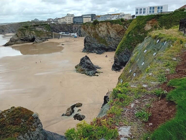
Newquay is renown for her stunning coastline, from the sandy playgrounds of Crantock and the Gannel to the rocky coves and clifftops of Newquay Bay and Watergate. The beauty of the coastline as well as the accessibility of the beaches and coves from Newquay are big reason for Newquay’s popularity as a tourist hotspot.
Following a referendum in 2019, whereupon 93% of local residents voted for the implementation of The Newquay Neighbourhood Development Plan. This document now forms the cornerstone by which future development proposals within Newquay and in particular the Newquay seafront are decided. This is highly significant for the further and future development of the Newquay coastline, because as part of the development plan, the entire coastal frontage, from the Gannel Estuary to the Newquay Parish boundary on Watergate Beach has been designated as Cornwall’s first Coastal Change Management Area (CCMA).
This means… amongst other things, Newquay has designated the following zones along the shoreline:
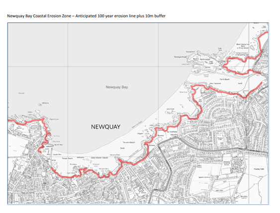
So what does this mean for coastal development in Newquay?
The Exclusion Zone – Proposals for development within the exclusion zone will not be supported.
The Coastal Erosion Vulnerability Zone – Development (or redevelopment of existing buildings) will only be permitted if:
This leaves large swathes of Newquay coastline in something of a development limbo, some of the most expensive and desirable properties in Newquay are may now find themselves unable to develop their sites further, and unable to sell-up for redevelopment if they fall within or close to the coastal erosion zone.
Furthermore, development (or redevelopment) proposals that require stabilisation, strengthening or other interference with the cliff will not be supported under the Neighbourhood Development Plan. This suggests that the previously preferred approach of meshing, rock bolting and otherwise stabilising the slope face to enable to the development to safely proceed, and to provide assurances over the planned 100-year design life of the development, may no longer be acceptable.
Property developers and land owners along the Newquay seafront may well be reaching for the paracetamol, as they realise their future plans for their sites may have gone up in smoke. However, it looks like this might be a taste of what I to come across Cornwall’s coastal communities, as local authorities, already operating under climate change emergancy measures imposed by Cornwall Council, start to roll out more CCMAs, with similiarly restrictive measures, in the not so distant future.
Take a look at our website for more information regarding Coastal Erosion and Coastal Vulnerability Assessments, in Newquay and elsewhere in Cornwall. Call or email Slope Stability Southwest on 07578855180 / [email protected] if you have any question or concerns about a site you are involved in.
Refer to the Newquay Neighbourhood Development Plan for more details including how the Coastal Change Management Area (CCMA) designation may affect your property of proposed development.
Article by Tim Green. MSc, FGS, CGeol